Westwoods Trails
10/24/2010
Blue Circle Trail Starting at Dunk Rock Road to Green Circle Trail, then Green Rectangle Trail to Orange Circle Trail, then Red Triangle to cross over to the White Circle Trail, then we took the Green Rectangle back to Dunk Rock Road.
Confused yet? 🙂 Maps of this Trail System are available in the CT Walk Book East and at the following website: http://guilfordlandtrust.org/wordpress/properties/westwoods
The Westwoods Trail System within the Cockaponset State Forest is a great place to get your feet wet in the world of hiking. It’s got a little taste of everything. If you stick mostly to the Rectangle, square, and triangle trails you’ll be in for pretty easy walking. If you want something more challenging check out the circle trails. Keep in mind that the Yellow Circle Trail is recommended only to experienced, agile, and energetic hikers. Based on what we saw of the White Circle trail I would heed that warning as it required some agility as well. Also, based on what we experienced of the White Circle Trail, we’re looking forward to heading back to do the Yellow Circle Trail soon.
All Photo’s by Ahren Niles. (Yes, including the one he’s in, he set the camera up for the conditions, I just aimed and pushed the button.)
Click the pictures to see a larger version.

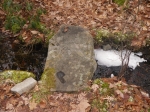
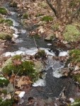
Ice along the Blue Circle Trail.

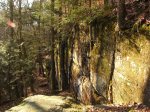
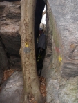
In a crevice along the White Circle Trail.

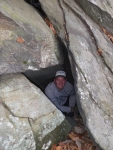
Sidetrack in the crevice.

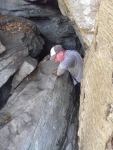
Squeezing through the last narrow bit of the crevice. We both had to take our packs off to fit.
Here’s a link to what my GPS tracked of our hike for the day. Pay no mind to the stats as they seem to be really off. There’s no way we hiked 11 miles, and there’s no way our max speed ever hit 7.83 miles/hour. Silly GPS.